3 Oct 1671 Wm. Hancock 700 acres in Lynnhaven Parrish in Lower Norfolk County on the Northne Side of the Easterne Branch of Elizabeth River …
p23 27 May 1673 – WM: West 400 ares in Lower Norfolk County in ye woods near the NORTH RIVER & on the Westerne side of a GREAT POQUOSON bounded on ye Eastern parts therewith beginning at ye side thereof funin from thence by marked trees drawne W 274 po then SW 68 po then S126 po then SSE 96 po then ENE 244 po to ye sd POQUOSON ye sd land due for transportation of 8 persons: JNO: JAMES, ABRAHAM JOHNSON, PETER VINTON, JEFFREY AYRES, WM: PEENE, ALICE MOON, ROBT: WILLS, WM: DIRKE.
(Note:- This Court Clerk is careless. He leaves letters as well as whole words out. AGW)
p25 23 Oct 1673 DANIELL MACOY … transportation of 2 persons: GEO: IVEY, HANNA IVEY
page 27 – 23 Oct 1673 Thomas Vicesimus Ivey 620 acres in Lower Norfolk County at the head of the Easterne Branch of Elizabeth River in the County of Lower Norfolk, 170 acres thereof being pt of a Patt: of 200 acres formerly granted to … Beginning at a corner tree of Wm: Hancocks land thence running by severall lines drawne first NNE 100 po then ESE 80 po then E by S 1/2 S 80 po then NE by E 1/2 E 246 po then S 192 po then W 56 po then S 1/2 W 100 po then S by W 1/2 W 10 po then W by N 310 po then N by W 86 po unto the first station. 170 acres due as aforesaid & 450 acres being due for trans: of 9 psons: THO: VICESIMU IVEY, ALICE IVEY, MARY IVEY, MARY EDEN, … a Negroe & an Indian…
p28 26 Oct 1673 (p474) GEO: Fowler … to a Quarter tree of WILL: HANCOCKS land…
p31 6 Nov 1673 ROBERT HODGES 280 acres in Lower Norfolk County being in LINHAVE on the WEST SIDE of SAMLL: BENNETTS CREEKE at the head of the CATTAYLE BRANCH, thence runs first NNW 46 po th: WSW 250 po then SSE 162 po th: NW 232 po then ENE 350 po then SSE 178 po unto the head of a branch then downe the SW side of that br: and up the NE side of anothr branch unto the head thereof and the first station, Sd 280 acres being ude as followeth 250 acres pte thereof formerly granted to SAVILL GASKINS by patt: dated 20 Oct 1661 and sold unto WILLIAM HODGE as by assignmt of the said Patt: as will appeare in Lower Norfolk records 29 Oct 1662. The other 30 acres being pte of a parcell of land of one LANCFIELDS patt: sould unto the sd WILLIAM HODGE and now the whole 280 acres being due to ROBERT HODGE as heire to his brother WILLIAM HODGE late deceased. (See Nugent pp 269, 415 Sevill Gaskin)
2 Mar 1673/4 (p506) THO: PIERCE 155 acres in WARWICK COUNTY and MULBERY ISLAND PISH bounded … a point neare WARWICK RIVER side … along Warwick River … mkd oak in GEO: HARWOODS line neare sd HARWOODS house … for trans: of 3 psons: WM; FFOARD (Ford), JOSEPH HABERD (or HUBERD), JNO: MILLS.
21 Sep 1674 GEO: PEARCE 2100 acres in Nansemond County. AMong the head right: THO: TURNER
p34 29 Nov 1674 JAMES HARRISON, JOHN BOWZEE, & ELIZ: MARGERETT, ANN & ELIN MOTT, orphans of Mr. GEO: MOTT – 9019 acres on the South side of Rappahannock River. PETER RIDLEY & WM: WEST two of the 180 head rights.

p37 9 Oct 1674 (p582) WM: WEST 656 acres in Lower Norfolk County on the East side of the NORTH RIVER 400 acres of which land was formerly granted unto the sd WEST by pattent dated 27 May 1673 & 256 acres bounded vizt: begin: at a corner maple by a poquoson of the river & runing E by N 92 po to a corner pine th: NE 82 po to a corner Holy thence E 60 po to a corner pine in his old line th: SW 68 po th: S 126 po th: SSE 96 po to a corner pine in his old line th: SW 68 po SE by E 31 po to a corner gum th: SW by W42 po to a corner gum th: WNW 1/2 Wly 214 po to the river th: N 1/2 Ely 164 po bounding on the rier and the Poquoson of the river to the first station for the trans: of 56 persons: WM: WEST, WM: WEST (sic), LAWRENCE BOUCHER, RICHARD HANDICK, HENRY SOUTHERNE

p48 5 Jun 1678 Richard Stanley 142 acres
p49 6 June 1678 (p636) WILLIAM COCKROFFT (sic) 510 acres in Lower Norfolk County beginning at a Point by a branch side dividin this land & CHARLES EGERTON …
p51 27 Sep 1678 (p657) WM: PORTEN … to MR. EGERTONS corner tree …
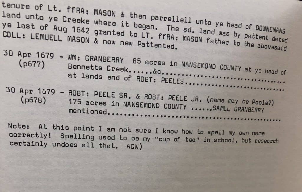
p52 30 Apr 1679 ROBT: PEELE SR. & ROBT PEELE JR. 175 acres in Nansemond County … SAMLL GRANBERRY mentioned
Butler Center , Little Rock, Arkansas
F232.N8 W29
1972